• Menu
    • Home
    • Online Mapping
      • Explore the Maps
      • Metadata
    • Visit the Lab
    • Order Maps & Data
      • County-Wide Digital Data
      • Digital Data by Tile
      • Featured Maps
      • Historical Maps
      • NKYmapLAB Maps
    • Key Performance Indicators
    • How Do I…
      • Become a Business Client
      • Contact LINK-GIS
      • Find Flood Zones
      • Find My City
      • Find My Polling Location
      • Use the LINK-GIS Map Viewer
      • Use the Park Finder Map Viewer
      • Locate Sex Offenders in My Area
      • Locate Survey Monuments
      • Retrieve Zoning Information
    • About LINK-GIS
      • About LINK-GIS
      • Contact LINK-GIS
        • Frequently Asked Questions
        • Control Network Recovery
      • LINK-GIS History: Achievements, Articles and Awards
      • Partners
      • GIS Team
    • Awards
  • Menu
    • Home
    • Online Mapping
      • Explore the Maps
      • Metadata
    • Visit the Lab
    • Order Maps & Data
      • County-Wide Digital Data
      • Digital Data by Tile
      • Featured Maps
      • Historical Maps
      • NKYmapLAB Maps
    • Key Performance Indicators
    • How Do I…
      • Become a Business Client
      • Contact LINK-GIS
      • Find Flood Zones
      • Find My City
      • Find My Polling Location
      • Use the LINK-GIS Map Viewer
      • Use the Park Finder Map Viewer
      • Locate Sex Offenders in My Area
      • Locate Survey Monuments
      • Retrieve Zoning Information
    • About LINK-GIS
      • About LINK-GIS
      • Contact LINK-GIS
        • Frequently Asked Questions
        • Control Network Recovery
      • LINK-GIS History: Achievements, Articles and Awards
      • Partners
      • GIS Team
    • Awards

Legend Widget


This widget draws the legends for any non-basemaps layers currently displayed in the LINK-GIS map viewer. This widget will update as the zoom level changes or data layers are turned on or off.

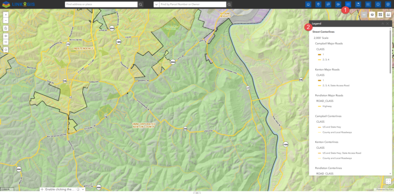
Close the widget by clicking on the “x” in the upper right hand corner of the widget, or clicking its icon in the toolbar.

  • Home
  • How Do I…
  • Use the LINK-GIS Map Viewer
  • Legend Widget

How Do I…

  • Become a Business Client
  • Contact LINK-GIS
  • Find Flood Zones
  • Find My City
  • Find My Polling Location
  • Use the LINK-GIS Map Viewer
    • About Widget
    • Basemap Gallery
    • Basemap Mashup Widget
    • Bookmark Widget
    • Coordinate Widget
    • Draw Widget
    • Enhanced Search Widget
    • Find an Address
    • Flood Widget
    • Legend Widget
    • Measure Widget
    • More Map Layers – Turning On and Off
    • My Property Info Widget
    • Navigation Controls
    • Opening the Viewer
    • Pictometry Widget
    • Pop-ups
    • Print Widget
    • Swipe
    • Toolbar
  • Use the Park Finder Map Viewer
    • Basemap Widget
    • Help Widget
    • Locate Widget
    • Navigation Controls
    • Opening the Park Finder Map
    • Pop-ups
    • Search Widget
    • Share Widget
    • Toolbar
  • Locate Sex Offenders in My Area
  • Locate Survey Monuments
  • Retrieve Zoning Information

LINK-GIS Disclaimer  •  Copyright @2016  •  Planning and Development Services of Kenton County