


LINK-GIS remains engaged fully in carrying out the responsibilities assigned to it by law, interlocal agreements, and contracts for professional services. We provide the following guidance to those who want or need to interact with our staff. The vast majority of the LINK-GIS/PDS’ staff is working from their homes, but you can communicate with them […]
How You Can Vote in the Kenton County General Election-November 3, 2020
VOTE BY MAIL: GOVOTEKY.COM – request a ballot. You need SSN and driver’s license. Deadline is October 9, 2020. Ballot is mailed. Call 392-1620- request a ballot. We can help you through portal. You need SSN and driver’s license. Deadline is October 9, 2020. Ballot is mailed Postage is pre-paid on return envelope. Don’t forget […]
Adjusted Operation Details for LINK-GIS
LINK-GIS/PDS offices in the Kenton County Government Center are open to the public now. In-house staffing levels continue to be guided by Governor Andy Beshear’s executive orders. All services assigned to PDS by state law, interlocal agreements, partnerships, and contracts for professional services will remain available online through our return and beyond. We extend the […]
Request for Proposals
Planning and Development Services of Kenton County (PDSKC), on behalf of the LINK-GIS Partnership, is accepting proposals from aerial survey firms for Aerial Imagery Acquisition, Digital Orthoimagery Production, LiDAR Acquisition, Digital Elevation Dataset Production and Photogrammetric Updates to, or New Compilation of, GIS Planimetric Mapping for Kenton and Campbell Counties in Kentucky. A zip-compressed file […]
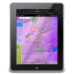
LINK-GIS Adds Pictometry Widget to the Map Viewer
Users of the LINK-GIS map viewer can now view oblique imagery in just a couple clicks. LINK-GIS contracted with EagleView (formerly Pictometry) to fly oblique imagery for Campbell and Kenton Counties in 2018. EagleView developed a widget for use on ESRI’s Java Script API applications, as a way to view their oblique imagery in the […]
NKYdroneLAB Selected by URISA as Distinguished System (Letter from URISA)
August 2, 2018 Trisha W. Brush, GISP Director of GIS Services Kenton and Campbell Counties of Kentucky 2332 Royal Drive Fort Mitchell KY 41017-2088 Dear Trisha: Congratulations! I am so pleased to inform you that “NKYdroneLAB” has been selected by URISA’s Exemplary Systems in Government (ESIG) Review Committee to receive recognition as a Distinguished System. […]
Have a couple of minutes? Help us with your opinion.
PDS, the managing partner of LINK-GIS, is conducting a Customer Satisfaction Survey. Please take the survey to help LINK-GIS/PDS understand how we can improve and what we are doing well.
Fiscal Court declares GIS Day in Kenton County
Kenton County Judge-Executive Kris Knochelmann and County Commissioners Beth Sewell, Jon Draud, and Joe Nienaber presented PDS staff with a GIS proclamation during their November 14, 2017 Fiscal Court meeting. The proclamation recognized Wednesday, November 15, 2017 as GIS Day in Kenton County. Louis Hill, AICP, GISP, Geospatial Data Analyst, and Ryan Hermann, Associate GIS […]
PDS services now include photography from ‘unmanned aerial vehicle’
PDS recently added video and photography capabilities from an unmanned aerial vehicle (UAV) to the services available to all Kenton County jurisdictions. Photos, videos, ortho-mosaics, 3D renderings, elevation profiles, volume calculations, digital terrain models, digital surface models, emergency services, accident reconstructions, and search and rescue flights are now available through its One Stop Shop Program. […]
LINK-GIS is an ever-growing treasure trove of geospatial data
LINK-GIS is all about data. Thirty-two years’ worth of data. Fourteen terabytes of data… a number that grows incrementally each day as the world changes around us. Consider this: · Over 2017 PDS processed 954 building permits; each new building prompts changes to GIS data. · PDS inspected 7,540 linear feet of surface asphalt and […]