• Menu
    • Home
    • Online Mapping
      • Explore the Maps
      • Metadata
    • Visit the Lab
    • Order Maps & Data
      • County-Wide Digital Data
      • Digital Data by Tile
      • Featured Maps
      • Historical Maps
      • NKYmapLAB Maps
    • Key Performance Indicators
    • How Do I…
      • Become a Business Client
      • Contact LINK-GIS
      • Find Flood Zones
      • Find My City
      • Find My Polling Location
      • Use the LINK-GIS Map Viewer
      • Use the Park Finder Map Viewer
      • Locate Survey Monuments
      • Retrieve Zoning Information
    • About LINK-GIS
      • About LINK-GIS
      • Contact LINK-GIS
        • Frequently Asked Questions
        • Control Network Recovery
      • LINK-GIS History: Achievements, Articles and Awards
      • Partners
      • GIS Team
    • Awards
  • Menu
    • Home
    • Online Mapping
      • Explore the Maps
      • Metadata
    • Visit the Lab
    • Order Maps & Data
      • County-Wide Digital Data
      • Digital Data by Tile
      • Featured Maps
      • Historical Maps
      • NKYmapLAB Maps
    • Key Performance Indicators
    • How Do I…
      • Become a Business Client
      • Contact LINK-GIS
      • Find Flood Zones
      • Find My City
      • Find My Polling Location
      • Use the LINK-GIS Map Viewer
      • Use the Park Finder Map Viewer
      • Locate Survey Monuments
      • Retrieve Zoning Information
    • About LINK-GIS
      • About LINK-GIS
      • Contact LINK-GIS
        • Frequently Asked Questions
        • Control Network Recovery
      • LINK-GIS History: Achievements, Articles and Awards
      • Partners
      • GIS Team
    • Awards

Fiscal Court declares GIS Day in Kenton County

December 26, 2017

Kenton County Judge-Executive Kris Knochelmann and County Commissioners Beth Sewell, Jon Draud, and Joe Nienaber 
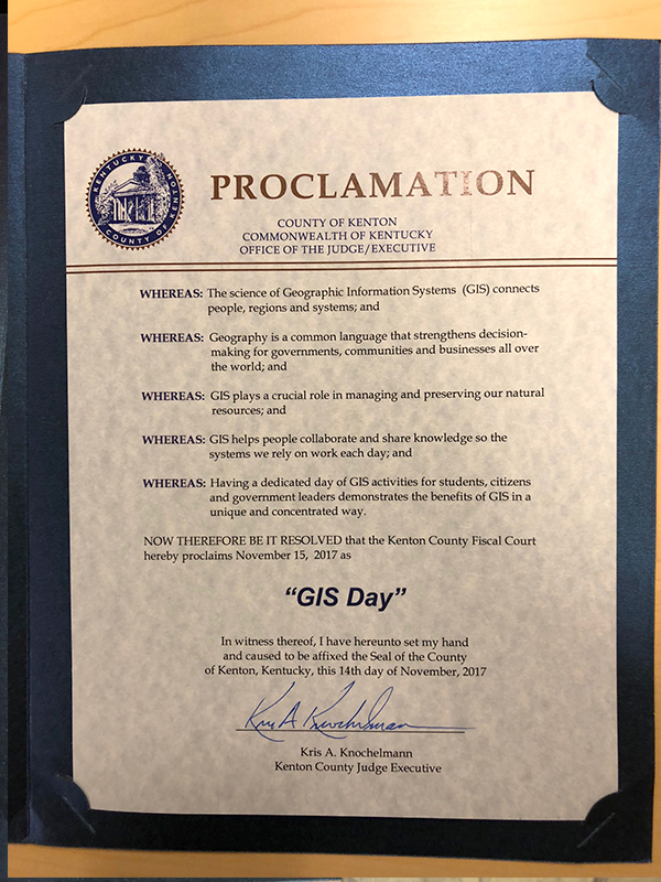
presented PDS staff with a GIS proclamation during their November 14, 2017 Fiscal Court meeting. The proclamation recognized Wednesday, November 15, 2017 as GIS Day in Kenton County.

Louis Hill, AICP, GISP, Geospatial Data Analyst, and Ryan Hermann, Associate GIS Specialist, attended the Fiscal Court meeting to accept the proclamation on behalf of PDS.

According to Hermann, “GIS Day is our single largest education and outreach event of the year. This year the Kenton County Academies of Innovation and Technology hosted our event and we were able to discuss GIS, mapping, analysis, programming, and UAV/d
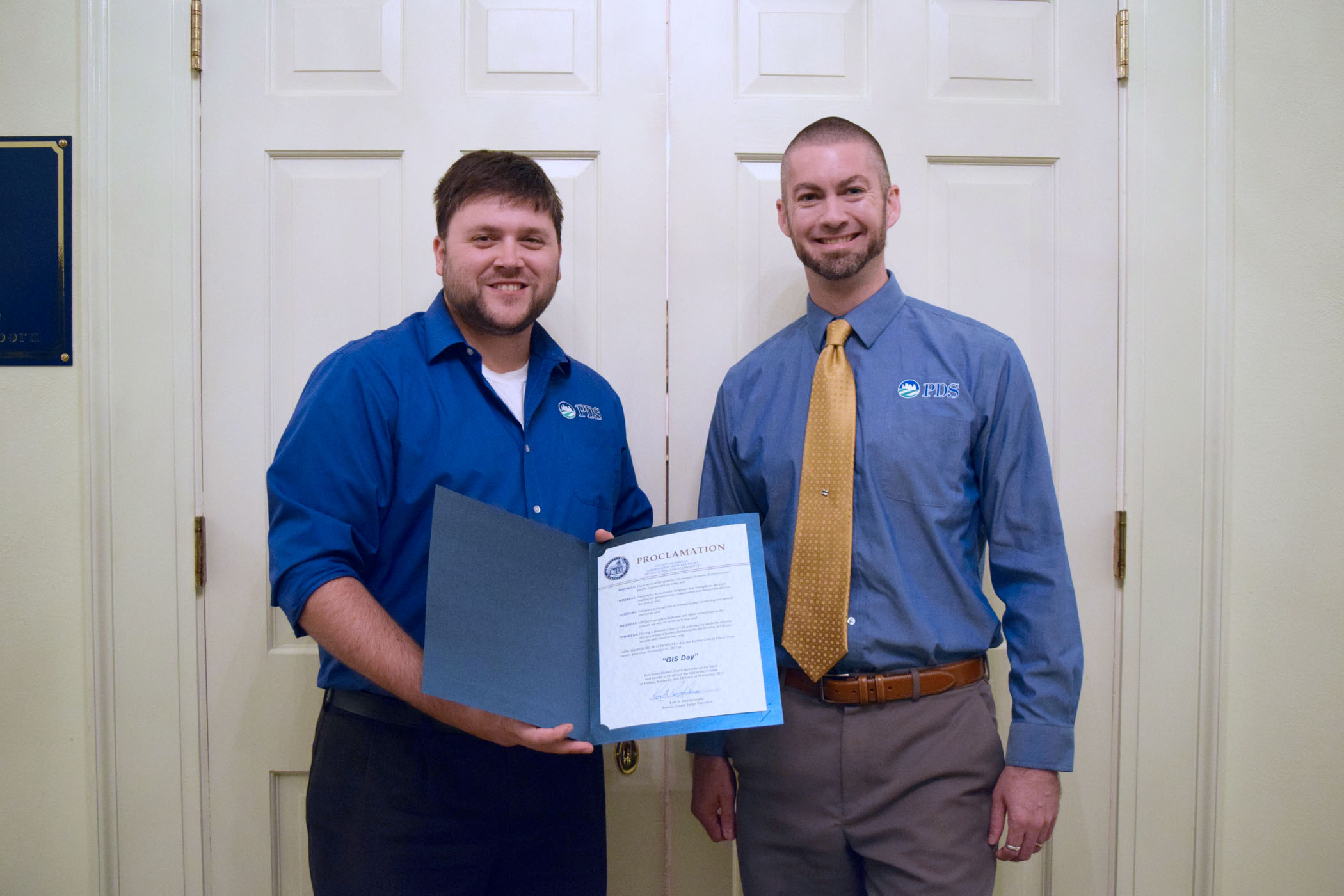
rone technologies with over 400 students.”

GIS (geographic information systems) is the mapping and analysis technology that PDS/LINK-GIS provides to the citizens, governments, and agencies in Kenton, Campbell, and Pendleton Counties.

For additional information about PDS’ GIS outreach offerings, email Ryan Hermann or Louis Hill, or call either of them at 859.331.8980.

LINK-GIS News, Outreach, Recognition
Campbell, GIS, GIS Day, Kenton, Kenton County, Kenton County Fiscal Court, Kentucky, Map, Northern Kentucky, PDS, Pendleton
PDS services now include photography from ‘unmanned aerial vehicle’
Have a couple of minutes? Help us with your opinion.
  • Home
  • LINK-GIS News
  • Recognition
  • Outreach
  • Fiscal Court declares GIS Day in Kenton County

Recent Articles

  • Adjusted Operation Details for LINK-GIS
  • How You Can Vote in the Kenton County General Election-November 3, 2020
  • Adjusted Operation Details for LINK-GIS

Archives

  • November 2020
  • October 2020
  • March 2020
  • January 2020
  • March 2019
  • August 2018
  • June 2018
  • December 2017
  • November 2017
  • September 2017
  • August 2017
  • July 2017
  • May 2017
  • April 2017
  • March 2017
  • February 2017
  • January 2017
  • October 2016
  • August 2016
  • July 2016
  • June 2016
  • March 2016
  • December 2015
  • October 2015
  • August 2015
  • February 2015
  • December 2014
  • October 2014
  • August 2014
  • July 2014
  • May 2014
  • April 2014
  • March 2014
  • February 2014
  • December 2013
  • November 2013
  • September 2013
  • August 2013
  • May 2013
  • March 2013
  • March 2012
  • January 2012
  • December 2011
  • February 2011
  • October 2010
  • September 2010
  • August 2010
  • July 2010
  • June 2010
  • March 2010
  • February 2010
  • January 2010
  • December 2009
  • November 2009
  • October 2009
  • September 2009
  • April 2009
  • March 2009
  • October 2008
  • August 2008
  • July 2008
  • May 2008
  • April 2008
  • March 2008
  • January 2008
  • December 2007
  • October 2007
  • August 2007
  • June 2007
  • May 2007
  • April 2007
  • February 2007
  • January 2007
  • November 2006
  • October 2006
  • August 2006
  • June 2006
  • May 2006
  • April 2006
  • February 2006
  • January 2006
  • December 2005
  • September 2005
  • April 2005
  • March 2005
  • February 2005
  • October 2003

LINK-GIS Disclaimer  •  Copyright @2016  •  Planning and Development Services of Kenton County