• Menu
    • Home
    • Online Mapping
      • Explore the Maps
      • Metadata
    • Visit the Lab
    • Order Maps & Data
      • County-Wide Digital Data
      • Digital Data by Tile
      • Featured Maps
      • Historical Maps
      • NKYmapLAB Maps
    • Key Performance Indicators
    • How Do I…
      • Become a Business Client
      • Contact LINK-GIS
      • Find Flood Zones
      • Find My City
      • Find My Polling Location
      • Use the LINK-GIS Map Viewer
      • Use the Park Finder Map Viewer
      • Locate Survey Monuments
      • Retrieve Zoning Information
    • About LINK-GIS
      • About LINK-GIS
      • Contact LINK-GIS
        • Frequently Asked Questions
        • Control Network Recovery
      • LINK-GIS History: Achievements, Articles and Awards
      • Partners
      • GIS Team
    • Awards
  • Menu
    • Home
    • Online Mapping
      • Explore the Maps
      • Metadata
    • Visit the Lab
    • Order Maps & Data
      • County-Wide Digital Data
      • Digital Data by Tile
      • Featured Maps
      • Historical Maps
      • NKYmapLAB Maps
    • Key Performance Indicators
    • How Do I…
      • Become a Business Client
      • Contact LINK-GIS
      • Find Flood Zones
      • Find My City
      • Find My Polling Location
      • Use the LINK-GIS Map Viewer
      • Use the Park Finder Map Viewer
      • Locate Survey Monuments
      • Retrieve Zoning Information
    • About LINK-GIS
      • About LINK-GIS
      • Contact LINK-GIS
        • Frequently Asked Questions
        • Control Network Recovery
      • LINK-GIS History: Achievements, Articles and Awards
      • Partners
      • GIS Team
    • Awards

LINK-GIS partners receive final delivery of 2014 aerial photography

August 29, 2014

aerial3To update the April 2014 edition of this newsletter, new aerial imagery of Kenton and Campbell Counties captured for LINK-GIS partners this spring has now been completely delivered. The new imagery provides some of the most detailed views of these counties ever seen. It also includes the capability to measure the vertical heights of buildings, towers, and other objects on the ground.

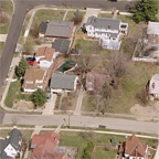
The imagery comes in two formats. The first provides an oblique or “birds-eye” view of the ground and includes the ability to measure heights of structures as well as to view a site from multiple directions. LINK-GIS has provided this capability in the past but the resolution of these 2014 images is more detailed than before. Coupled with the vertical measurement capability enabled by LINK-GIS’ LiDAR elevation data set, users will have the most detailed view ever of the two counties.

The second format was delivered at the end of July and provides a straight down or “nadir” view of the ground. This imagery is also more detailed than in the past. It includes corrections made to account for the hills and valleys of the surface. This imagery can be displayed as a backdrop to the other layers maintained by LINK-GIS, including city and zoning boundaries, roads, building footprints, drainage and many others.

This imagery is now being loaded into the LINK-GIS system and being assembled into a mosaic for use by all LINK-GIS partners. Local law enforcement and emergency response agencies will also find this information valuable when responding to dangerous situations.

These new aerial images will be available on the LINK-GIS website by the end of September.

Data Development, LINK-GIS News, Technology
2014 Aerial Photography, Campbell, Delivery, Imagery, Images, Kenton, LINK-GIS, Oblique, Partners, Resolution
Know your boundaries: GIS and GPS saves local county thousands
Senior staffer’s service nets President’s Award at annual KAMP conference
  • Home
  • LINK-GIS News
  • Technology
  • Data Development
  • LINK-GIS partners receive final delivery of 2014 aerial photography

Recent Articles

  • Adjusted Operation Details for LINK-GIS
  • How You Can Vote in the Kenton County General Election-November 3, 2020
  • Adjusted Operation Details for LINK-GIS

Archives

  • November 2020
  • October 2020
  • March 2020
  • January 2020
  • March 2019
  • August 2018
  • June 2018
  • December 2017
  • November 2017
  • September 2017
  • August 2017
  • July 2017
  • May 2017
  • April 2017
  • March 2017
  • February 2017
  • January 2017
  • October 2016
  • August 2016
  • July 2016
  • June 2016
  • March 2016
  • December 2015
  • October 2015
  • August 2015
  • February 2015
  • December 2014
  • October 2014
  • August 2014
  • July 2014
  • May 2014
  • April 2014
  • March 2014
  • February 2014
  • December 2013
  • November 2013
  • September 2013
  • August 2013
  • May 2013
  • March 2013
  • March 2012
  • January 2012
  • December 2011
  • February 2011
  • October 2010
  • September 2010
  • August 2010
  • July 2010
  • June 2010
  • March 2010
  • February 2010
  • January 2010
  • December 2009
  • November 2009
  • October 2009
  • September 2009
  • April 2009
  • March 2009
  • October 2008
  • August 2008
  • July 2008
  • May 2008
  • April 2008
  • March 2008
  • January 2008
  • December 2007
  • October 2007
  • August 2007
  • June 2007
  • May 2007
  • April 2007
  • February 2007
  • January 2007
  • November 2006
  • October 2006
  • August 2006
  • June 2006
  • May 2006
  • April 2006
  • February 2006
  • January 2006
  • December 2005
  • September 2005
  • April 2005
  • March 2005
  • February 2005
  • October 2003

LINK-GIS Disclaimer  •  Copyright @2016  •  Planning and Development Services of Kenton County