• Menu
    • Home
    • Online Mapping
      • Explore the Maps
      • Metadata
    • Visit the Lab
    • Order Maps & Data
      • County-Wide Digital Data
      • Digital Data by Tile
      • Featured Maps
      • Historical Maps
      • NKYmapLAB Maps
    • Key Performance Indicators
    • How Do I…
      • Become a Business Client
      • Contact LINK-GIS
      • Find Flood Zones
      • Find My City
      • Find My Polling Location
      • Use the LINK-GIS Map Viewer
      • Use the Park Finder Map Viewer
      • Locate Survey Monuments
      • Retrieve Zoning Information
    • About LINK-GIS
      • About LINK-GIS
      • Contact LINK-GIS
        • Frequently Asked Questions
        • Control Network Recovery
      • LINK-GIS History: Achievements, Articles and Awards
      • Partners
      • GIS Team
    • Awards
  • Menu
    • Home
    • Online Mapping
      • Explore the Maps
      • Metadata
    • Visit the Lab
    • Order Maps & Data
      • County-Wide Digital Data
      • Digital Data by Tile
      • Featured Maps
      • Historical Maps
      • NKYmapLAB Maps
    • Key Performance Indicators
    • How Do I…
      • Become a Business Client
      • Contact LINK-GIS
      • Find Flood Zones
      • Find My City
      • Find My Polling Location
      • Use the LINK-GIS Map Viewer
      • Use the Park Finder Map Viewer
      • Locate Survey Monuments
      • Retrieve Zoning Information
    • About LINK-GIS
      • About LINK-GIS
      • Contact LINK-GIS
        • Frequently Asked Questions
        • Control Network Recovery
      • LINK-GIS History: Achievements, Articles and Awards
      • Partners
      • GIS Team
    • Awards

Access 30+ pieces of detailed property information with a single click

October 9, 2015

LINKGISLINK-GIS’ new map viewer tool was put into service recently. Following an effort LG_viewer
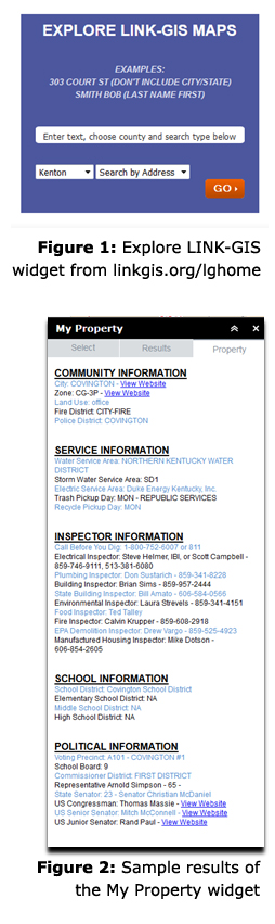
to beef up the information available with one click of the mouse, Map Viewer will now serve up numerous levels of property information in a quick, simple, and concise manner.

“One of our top priorities was to pull information from many sources into one list,” said Christy Powell, GISP, PDS’ senior GIS programmer. These data are being pulled from over 30 sources including community information, utility services, inspector contacts, and school and political districts.

“Although this information had been available on the previous version, the new website simplifies the process of getting results,” said Joe Busemeyer, GISP, PDS’ principal GIS programmer, who along with Powell created the new map viewer tool.

Powell and Busemeyer explained how simple the new tool is to use.

From the LINK-GIS homepage, find the Explore LINK-GIS Maps section on the bottom left side of the page (see Figure 1). Type the name or address you’re looking to find, choose the county and search type, then click GO.

The LINK-GIS Map Viewer will open and provide the search results. Click on the intended parcel from the list and get the detailed information along with a map of the property (see Figure 2).

“We created a similar list for flood plain information that includes many items from the FEMA floodplain information in one place,” said Busemeyer.

Access to that information is also a single click away on the water drop icon near the top right of the Map Viewer. Information passed from the Explore LINK-GIS Maps widget on the LINK-GIS homepage will automatically populate that widget.

“I hate having to type the exact same information several times on a website,” said Powell. “This new Map Viewer capability should help with that.”

Powell said that PDS’ programming team will continue to add innovative features to the online mapping options for the LINK-GIS website. In addition to the Map Viewer, there is already a Park Finder website available and a polling place locator in development that are aimed at niche interest groups.

Collaboration, Technology
Data, Easy Access, LINK-GIS, Map Viewer, Property, Single Click
GIS staff provides data to KY CMRS Board, brings $1.1M back to NKY
Gov. Beshear declares October 12th the beginning of GIS Week
  • Home
  • Technology
  • Collaboration
  • Access 30+ pieces of detailed property information with a single click

Recent Articles

  • Adjusted Operation Details for LINK-GIS
  • How You Can Vote in the Kenton County General Election-November 3, 2020
  • Adjusted Operation Details for LINK-GIS

Archives

  • November 2020
  • October 2020
  • March 2020
  • January 2020
  • March 2019
  • August 2018
  • June 2018
  • December 2017
  • November 2017
  • September 2017
  • August 2017
  • July 2017
  • May 2017
  • April 2017
  • March 2017
  • February 2017
  • January 2017
  • October 2016
  • August 2016
  • July 2016
  • June 2016
  • March 2016
  • December 2015
  • October 2015
  • August 2015
  • February 2015
  • December 2014
  • October 2014
  • August 2014
  • July 2014
  • May 2014
  • April 2014
  • March 2014
  • February 2014
  • December 2013
  • November 2013
  • September 2013
  • August 2013
  • May 2013
  • March 2013
  • March 2012
  • January 2012
  • December 2011
  • February 2011
  • October 2010
  • September 2010
  • August 2010
  • July 2010
  • June 2010
  • March 2010
  • February 2010
  • January 2010
  • December 2009
  • November 2009
  • October 2009
  • September 2009
  • April 2009
  • March 2009
  • October 2008
  • August 2008
  • July 2008
  • May 2008
  • April 2008
  • March 2008
  • January 2008
  • December 2007
  • October 2007
  • August 2007
  • June 2007
  • May 2007
  • April 2007
  • February 2007
  • January 2007
  • November 2006
  • October 2006
  • August 2006
  • June 2006
  • May 2006
  • April 2006
  • February 2006
  • January 2006
  • December 2005
  • September 2005
  • April 2005
  • March 2005
  • February 2005
  • October 2003

LINK-GIS Disclaimer  •  Copyright @2016  •  Planning and Development Services of Kenton County