
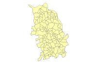
Watersheds (Campbell, Kenton and Pendleton Counties)
Tags
Kentucky, Surface, Kenton County, Campbell County, Pendleton County, Watershed, Drainage, Geomorph, Kentucky Geological Survey
Summary
Watersheds and contributing areas for watersheds in Northern Kentucky. Water resource planning and water quality management.
Description
14-digit, U.S.G.S. Hydrologic Units. The HUC layer was created by the USGS using ARC/INFO Geographic Information System (GIS) software and attributed to the 11- and 14-digit hydrologic unit code by the NRCS. The basis for selection of 11- and 14-digit hydrologic units is named streams on 1:100,000 scale maps. All named streams on 1:100,000 scale maps had basin boundaries delineated and digitized from 1:24,000 scale maps.
This subset for the LINK-GIS Consortium contains all 14 digit HUC’s that intersect Kenton Campbell or Pendelton Counties. This includes watersheds in the Licking River Basin, The Ohio River Basin as well as one HUC in the Kentucky River Basin. This data was originally published by the Kentucky Geological Survey see the below link for updated or a larger extent http://www.uky.edu/KGS/gis/hucfinder.htm
Credits
USGS, United States Geological Survey, Kentucky Geological Survey, LINK-GIS, Planning and Development Services of Kenton County (PDS)
Use limitations
All Users hereby acknowledge that PDS, LINK-GIS and any, or all, of its partners or employees accept no liability for use of this Data Product. These Data Products have not been prepared for, and are not suitable for engineering, or surveying purposes. Generally, these Data Products do not represent on-the-ground surveys, but rather represent the approximate relative location of boundaries and features. These Data Products are for general planning purposes only, no other intent is implied. Products should not be used for making financial or any other commitments.
PDS, LINK-GIS and any, or all, of its partners or employees provide these Data Products with the understanding that they are not guaranteed to be accurate, correct or complete and conclusions drawn from the Data Products are the responsibility of the User. While every effort has been made to ensure the accuracy, correctness and timeliness of materials presented anywhere within the Data Products, PDS, LINK-GIS and any, or all, of its partners or employees assumes no responsibility for errors or omissions, even if advised of the possibility of such damage.
Extent
| West | -84.697469 | East | -84.145121 |
| North | 39.122274 | South | 38.491453 |
Scale Range
Maximum (zoomed in) 1:5,000
Minimum (zoomed out) 1:500,000
Campbell County
- Address Points
- Buildings
- Building Accessories
- Centerlines
- City Boundaries
- Condominiums
- County Boundary
- Parcels
- Representative Districts
- Roads (edge of pavement)
- School Districts
- School Facilities
- Senatorial Districts
- Voting Polls
- Voting Precincts
- Zip Codes
- Zoning
Kenton County
- Address Points
- Buildings
- Centerlines
- City Boundaries
- Condominiums
- County Boundary
- Parcels
- Police Stations
- Roads (edge of pavement)
- Representative Districts
- School Districts
- School Facilities
- Senatorial Districts
- Sidewalks
- Voting Polls
- Voting Precincts
- Zip Codes
- Zoning
Pendleton County
- Aerial Photography 2020
- Aircare Landing Zones
- Buildings
- Centerlines
- City Boundaries
- County Boundary
- Geology
- Parcels
- Railroads
- Representative Districts
- School Board
- School Facilities
- Senatorial Districts
- Soils
- Topography
- Voting Polls
- Voting Precincts
Region
- Aerial Photography 2023 (CC and KC)
- Aerial Photography 2025
- Aircare Landing Zones (CC and KC)
- Control Points
- Creeks and Streams (CC and KC)
- Geology (CC and KC)
- Hospitals
- Libraries
- Museums
- NKWD – Hydrants (CC and KC)
- NKWD – Water Mains (CC and KC)
- Parks
- Railroads (CC and KC)
- SD1 – Sanitary Lines (CC and KC)
- SD1 – Sanitary Structures (CC and KC)
- SD1 – Storm Lines (CC and KC)
- SD1 – Storm Structures (CC and KC)
- Soils (CC and KC)
- Swimming Pools (CC and KC)
- Topography (CC and KC)
- Watersheds
