
Voting Polls Kenton County
Tags
Polls, Vote, Kenton County, Kenton County Clerk, Kentucky, LINK-GIS, Planning and Development Services of Kenton County, PDS
Summary
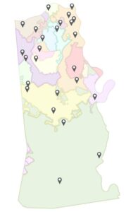
This data represents the point locations for polling places in Kenton County. This data includes the precinct name, name and address of the polling place as well as a link to a photo of the polling place. This Polling places in Kenton County Data Product is primarily intended for display, analysis, and mapping for current planning purposes, community development projects, and GIS-related analyses. The Polling places in Kenton County Data Product is not intended for property taxation purposes. Boundaries typically follow parcel boundary data if provided. This Polling places in Kenton County Data Product may change at any time, with or without notice. This data maintained by the Kenton County Clerk, and the points are geocoded by LINK-GIS
Description
This data represents the point locations for polling places in Kenton County. This data includes the precinct name, name and address of the polling place as well as a link to a photo of the polling place. This Polling places in Kenton County Data Product is primarily intended for display, analysis, and mapping for current planning purposes, community development projects, and GIS-related analyses. The Polling places in Kenton County Data Product is not intended for property taxation purposes. Boundaries typically follow parcel boundary data if provided. This Polling places in Kenton County Data Product may change at any time, with or without notice. This data maintained by the Kenton County Clerk, and the points are geocoded by LINK-GIS
Credits
LINK-GIS, Kentucky, Planning and Development Services of Kenton County, PDS, Kenton County Clerk
https://kentoncountykyclerk.com/election-day-voting-locations/
Use limitations
All Users hereby acknowledge that PDS, LINK-GIS and any, or all, of its partners or employees accept no liability for use of this Data Product. These Data Products have not been prepared for, and are not suitable for engineering, or surveying purposes. Generally, these Data Products do not represent on-the-ground surveys, but rather represent the approximate relative location of boundaries and features. These Data Products are for general planning purposes only, no other intent is implied. Products should not be used for making financial or any other commitments.
PDS, LINK-GIS and any, or all, of its partners or employees provide these Data Products with the understanding that they are not guaranteed to be accurate, correct or complete and conclusions drawn from the Data Products are the responsibility of the User. While every effort has been made to ensure the accuracy, correctness and timeliness of materials presented anywhere within the Data Products, PDS, LINK-GIS and any, or all, of its partners or employees assumes no responsibility for errors or omissions, even if advised of the possibility of such damage.
Extent
West -84.611508 East -84.459212
North 39.096226 South 38.826997
Scale Range
There is no scale range for this item.
Campbell County
- Address Points
- Buildings
- Building Accessories
- Centerlines
- City Boundaries
- Condominiums
- County Boundary
- Parcels
- Representative Districts
- Roads (edge of pavement)
- School Districts
- School Facilities
- Senatorial Districts
- Voting Polls
- Voting Precincts
- Zip Codes
- Zoning
Kenton County
- Address Points
- Buildings
- Centerlines
- City Boundaries
- Condominiums
- County Boundary
- Parcels
- Police Stations
- Roads (edge of pavement)
- Representative Districts
- School Districts
- School Facilities
- Senatorial Districts
- Sidewalks
- Voting Polls
- Voting Precincts
- Zip Codes
- Zoning
Pendleton County
- Aerial Photography 2020
- Aircare Landing Zones
- Buildings
- Centerlines
- City Boundaries
- County Boundary
- Geology
- Parcels
- Railroads
- Representative Districts
- School Board
- School Facilities
- Senatorial Districts
- Soils
- Topography
- Voting Polls
- Voting Precincts
Region
- Aerial Photography 2023 (CC and KC)
- Aerial Photography 2025
- Aircare Landing Zones (CC and KC)
- Control Points
- Creeks and Streams (CC and KC)
- Geology (CC and KC)
- Hospitals
- Libraries
- Museums
- NKWD – Hydrants (CC and KC)
- NKWD – Water Mains (CC and KC)
- Parks
- Railroads (CC and KC)
- SD1 – Sanitary Lines (CC and KC)
- SD1 – Sanitary Structures (CC and KC)
- SD1 – Storm Lines (CC and KC)
- SD1 – Storm Structures (CC and KC)
- Soils (CC and KC)
- Swimming Pools (CC and KC)
- Topography (CC and KC)
- Watersheds
