

 Louis Hill, AICP, GISP, a geospatial data analyst with PDS was elected recently to be the next president of the Kentucky Association of Mapping Professionals (KAMP). He will serve on the KAMP board for three years, in the role of president-elect in 2017, president in 2018 and past-president in 2019.
“KAMP continues to experience growth in its membership… which is great but can also present challenges,” said Hill. “We need to make sure that we continue to offer training, networking opportunities, and services to our members that they can’t find anywhere else.”
The Kentucky Association of Mapping Professionals was formed to:
1. foster the understanding and improvement of the management and use of geospatial information throughout the Commonwealth of Kentucky in all levels of government, academia, and the private sector; and
2. provide a mechanism for dialogue and education regarding geospatial information issues of concern or interest to all Kentucky professionals involved in the collection, processing, analysis, use, and maintenance of geospatial information.
To further this mission, KAMP provides an annual series of low-cost and no-cost training options throughout Kentucky. The event formats vary, but they are typically webinars, formal presentations and hands-on trainings conducted by distinguished industry speakers.
“The geospatial and mapping industry is expected to see above average growth over the next decade,” according to Hill. “We want to be able to keep our membership at the front of that trend.”
This year’s conference will be held at the Galt House in Louisville on September 5, 6 and 7.
“It’s the best place to learn the latest mapping technologies, establish yourself, network, get involved, present, and contribute to the geospatial and mapping profession in the Commonwealth of Kentucky,” concluded Hill.
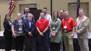 KAMP Executive Board: L-R, Meghan Dunn (AECOM), President; Michelle Bough (Stantec), Director; Louis Hill (PDS), President Elect; Vince DiNoto (KCTCS Jefferson), Director; David Siskin (Precision Products), Secretary; Lane Hartman (Hartman Spatial Data Consulting, LLC), Director; Angela Scott (Trideum), Treasurer; Stephen Chino (City of Paducah), Director; Tim Fields (Floyd County 911), Director; Lance Morris (Owensboro – Daviess County GIS Consortium), Past President. Not pictured: Jennifer Miller (Kentucky Division of Water), Director.