• Menu
    • Home
    • Online Mapping
      • Explore the Maps
      • Metadata
    • Visit the Lab
    • Order Maps & Data
      • County-Wide Digital Data
      • Digital Data by Tile
      • Featured Maps
      • Historical Maps
      • NKYmapLAB Maps
    • Key Performance Indicators
    • How Do I…
      • Become a Business Client
      • Contact LINK-GIS
      • Find Flood Zones
      • Find My City
      • Find My Polling Location
      • Use the LINK-GIS Map Viewer
      • Use the Park Finder Map Viewer
      • Locate Survey Monuments
      • Retrieve Zoning Information
    • About LINK-GIS
      • About LINK-GIS
      • Contact LINK-GIS
        • Frequently Asked Questions
        • Control Network Recovery
      • LINK-GIS History: Achievements, Articles and Awards
      • Partners
      • GIS Team
    • Awards
  • Menu
    • Home
    • Online Mapping
      • Explore the Maps
      • Metadata
    • Visit the Lab
    • Order Maps & Data
      • County-Wide Digital Data
      • Digital Data by Tile
      • Featured Maps
      • Historical Maps
      • NKYmapLAB Maps
    • Key Performance Indicators
    • How Do I…
      • Become a Business Client
      • Contact LINK-GIS
      • Find Flood Zones
      • Find My City
      • Find My Polling Location
      • Use the LINK-GIS Map Viewer
      • Use the Park Finder Map Viewer
      • Locate Survey Monuments
      • Retrieve Zoning Information
    • About LINK-GIS
      • About LINK-GIS
      • Contact LINK-GIS
        • Frequently Asked Questions
        • Control Network Recovery
      • LINK-GIS History: Achievements, Articles and Awards
      • Partners
      • GIS Team
    • Awards

Staff rolls out database of subdivision lots available, developed

April 3, 2017

suburbs-143x116Want to know more about lot availability of subdivisions in Kenton County? Through the collaborative efforts of PDS staff, new subdivision data has been created and is now available on the new LINK-GIS Development Analyst map viewer.

Two members of the GIS team, Joe Busemeyer, GISP and Steve Lilly, PLS, GISP, CPII; have utilized the power of GIS Model Builder to extract “vacant” and “developed” parcel information in the active subdivisions of Kenton County.

The project began as a discussion regarding information that is commonly requested at PDS. What subdivisions have lots available? How many parcels are available and how many have been developed in said subdivision? Is the subdivision single or multi-family? From there, Busemeyer began looking at the GIS data layers that already exist. Using the Model Builder technology in the ESRI GIS software, he was able to create a series of models that intersect existing GIS data layers, run calculations, extract new information and generate a series of new GIS database layers to answer these questions. During this process Busemeyer realized that some of the GIS data needed some updates and upgrades.

Lilly, who maintains many of the GIS layers involving development in Kenton County, utilized his expertise of this information for this project. He performed extensive quality control on the Preliminary Plat layer, which represents active and non-active subdivisions in the county and is one of the key GIS layers used in the models Busemeyer developed.

After many rounds of testing and tweaking the data and models, they were able to create the GIS layers needed to answer the subdivision questions.

Busemeyer then created the new Development Analyst map viewer, added the new subdivision GIS data, and configured pop-ups for the new GIS layers. Now when users click on a subdivision in the map viewer, they will see a window showing information pertaining to that subdivision. Adding these dynamic layers allow users to interact with the data, such as turLG_screen
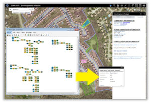
ning the layers on and off and clicking on the features for more information.

In addition to the map viewer, Lilly developed a user-friendly spreadsheet that could be exported onto the website. The document displays commonly requested key pieces of information. Developments are organized by their city and display the acreage, total lots planned, and total lots built. Each development name is also hyperlinked and will open to its location on the over-all development plan.

Through the collaboration of PDS staff members and innovative use of GIS technology, subdivision information is readily available in just a few clicks of the mouse.

To try out this new function, visit linkgis.org and start exploring today!

Collaboration, Data Development, LINK-GIS News, Technology
GIS, Kenton County, LINK-GIS, linkgis.org, Map Viewer, Model Builder, PDS, Subdivision
GIS, Planning directors speak to national audience on collaboration
In-house GIS collaboration earns Esri Special Achievement Award
  • Home
  • LINK-GIS News
  • Technology
  • Collaboration
  • Data Development
  • Staff rolls out database of subdivision lots available, developed

Recent Articles

  • Adjusted Operation Details for LINK-GIS
  • How You Can Vote in the Kenton County General Election-November 3, 2020
  • Adjusted Operation Details for LINK-GIS

Archives

  • November 2020
  • October 2020
  • March 2020
  • January 2020
  • March 2019
  • August 2018
  • June 2018
  • December 2017
  • November 2017
  • September 2017
  • August 2017
  • July 2017
  • May 2017
  • April 2017
  • March 2017
  • February 2017
  • January 2017
  • October 2016
  • August 2016
  • July 2016
  • June 2016
  • March 2016
  • December 2015
  • October 2015
  • August 2015
  • February 2015
  • December 2014
  • October 2014
  • August 2014
  • July 2014
  • May 2014
  • April 2014
  • March 2014
  • February 2014
  • December 2013
  • November 2013
  • September 2013
  • August 2013
  • May 2013
  • March 2013
  • March 2012
  • January 2012
  • December 2011
  • February 2011
  • October 2010
  • September 2010
  • August 2010
  • July 2010
  • June 2010
  • March 2010
  • February 2010
  • January 2010
  • December 2009
  • November 2009
  • October 2009
  • September 2009
  • April 2009
  • March 2009
  • October 2008
  • August 2008
  • July 2008
  • May 2008
  • April 2008
  • March 2008
  • January 2008
  • December 2007
  • October 2007
  • August 2007
  • June 2007
  • May 2007
  • April 2007
  • February 2007
  • January 2007
  • November 2006
  • October 2006
  • August 2006
  • June 2006
  • May 2006
  • April 2006
  • February 2006
  • January 2006
  • December 2005
  • September 2005
  • April 2005
  • March 2005
  • February 2005
  • October 2003

LINK-GIS Disclaimer  •  Copyright @2016  •  Planning and Development Services of Kenton County