
Roads (Edge of Pavement) Campbell County
Tags
model, stereopair, planimetric, remote sensing, road, transportation, paved, unpaved, road edge, driveway, parking lot, paved road edge, unpaved road edge, bridge, paved driveway (100 ft.), unpaved driveway (100 ft.), underpass, trail, off road trail, vehicle trail, paved parking lot, unpaved parking lot, hidden feature
Summary
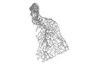
Planimetric data is used to represent typical urban features, in this case roads categorized as Paved road edge, Unpaved road edge, Bridge, Paved driveway (over 100 ft), Unpaved driveway (over 100 ft.), Underpass, Trail (off road / vehicle), Paved parking lot, Unpaved parking lot, and Hidden feature.
Description
Planimetric road data was collected in ArcGIS Geodatabase format from stereopairs in the Northern Kentucky Area Planning Commission area of interest.
Credits
Photo Science, Inc. flew the LiDAR and Aerial Imagery and processed the data.
Use limitations
LINK-GIS makes no representations, guarantees, or warranties as to the accuracy, completeness, currency, or suitability of information provided. LINK-GIS specifically disclaims any and all liability for any claims or damages that may result from providing this information, including any websites maintained by third parties and linked to this data. LINK-GIS makes no effort to independently verify, and does not exert editorial control over information on pages outside of the “linkgis.org” domain.
LINK-GIS value added data, LINK-GIS and any of its partners or employees except no liability for use of this data
Extent
West -84.505095 East -84.237708
North 39.117587 South 38.807306
Scale Range
There is no scale range for this item.
Campbell County
- Address Points
- Buildings
- Building Accessories
- Centerlines
- City Boundaries
- Condominiums
- County Boundary
- Parcels
- Representative Districts
- Roads (edge of pavement)
- School Districts
- School Facilities
- Senatorial Districts
- Voting Polls
- Voting Precincts
- Zip Codes
- Zoning
Kenton County
- Address Points
- Buildings
- Centerlines
- City Boundaries
- Condominiums
- County Boundary
- Parcels
- Police Stations
- Roads (edge of pavement)
- Representative Districts
- School Districts
- School Facilities
- Senatorial Districts
- Sidewalks
- Voting Polls
- Voting Precincts
- Zip Codes
- Zoning
Pendleton County
- Aerial Photography 2020
- Aircare Landing Zones
- Buildings
- Centerlines
- City Boundaries
- County Boundary
- Geology
- Parcels
- Railroads
- Representative Districts
- School Board
- School Facilities
- Senatorial Districts
- Soils
- Topography
- Voting Polls
- Voting Precincts
Region
- Aerial Photography 2023 (CC and KC)
- Aerial Photography 2025
- Aircare Landing Zones (CC and KC)
- Control Points
- Creeks and Streams (CC and KC)
- Geology (CC and KC)
- Hospitals
- Libraries
- Museums
- NKWD – Hydrants (CC and KC)
- NKWD – Water Mains (CC and KC)
- Parks
- Railroads (CC and KC)
- SD1 – Sanitary Lines (CC and KC)
- SD1 – Sanitary Structures (CC and KC)
- SD1 – Storm Lines (CC and KC)
- SD1 – Storm Structures (CC and KC)
- Soils (CC and KC)
- Swimming Pools (CC and KC)
- Topography (CC and KC)
- Watersheds
