
City Boundaries Campbell County
Tags
City limits, City Boundaries, City boundary lines, LINK-GIS, Planning and Development Services of Kenton County, PDS, Location, Planning, Kentucky, Campbell County
Summary
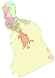
The Campbell County City Boundary layer displays the area covered by the cities in Campbell County and its boundaries. This Campbell County City Boundary Data Product is primarily intended for display, analysis, and mapping for current planning purposes, community development projects, and GIS-related analyses. The Campbell County City Boundary data contained in this data set are not intended for property taxation purposes. This Campbell County City Boundary Data Product is stored, edited and maintained as polygon geometry. This Campbell County City Boundary Data Product may change at any time, with or without notice.
Description
The Campbell County City Boundary layer displays the area covered by the cities in Campbell County and its boundaries. Campbell County jurisdictions are City of Alexandria, City of Bellevue, City of California, City of Crestview, City of Cold Spring, City of Dayton, City of Fort Thomas, City of Highland Heights, City of Melbourne, City of Mentor, City of Newport, City of Silver Grove, City of Southgate, City of Wilder, City of Woodlawn and Unincorporated Campbell County.
This Campbell County City Boundary Data Product is primarily intended for display, analysis, and mapping for current planning purposes, community development projects, and GIS-related analyses. The Campbell County City Boundary data contained in this data set are not intended for property taxation purposes. This Campbell County City Boundary Data Product is stored, edited and maintained as polygon geometry. This Campbell County City Boundary Data Product may change at any time, with or without notice.
Credits
Office of the Kentucky Secretary of State, Campbell County and its jurisdictions, LINK-GIS, Planning and Development Services of Kenton County (PDS)
Use limitations
All Users hereby acknowledge that PDS, LINK-GIS and any, or all, of its partners or employees accept no liability for use of this Data Product. These Data Products have not been prepared for, and are not suitable for engineering, or surveying purposes. Generally, these Data Products do not represent on-the-ground surveys, but rather represent the approximate relative location of boundaries and features. These Data Products are for general planning purposes only; no other intent is implied. Products should not be used for making financial or any other commitments.
PDS, LINK-GIS and any, or all, of its partners or employees provide these Data Products with the understanding that they are not guaranteed to be accurate, correct or complete and conclusions drawn from the Data Products are the responsibility of the User. While every effort has been made to ensure the accuracy, correctness and timeliness of materials presented anywhere within the Data Products, PDS, LINK-GIS and any, or all, of its partners or employees assumes no responsibility for errors or omissions, even if advised of the possibility of such damage.
Extent
West -84.506679 East -84.231854
North 39.122211 South 38.805587
Scale Range
There is no scale range for this item.
Campbell County
- Address Points
- Buildings
- Building Accessories
- Centerlines
- City Boundaries
- Condominiums
- County Boundary
- Parcels
- Representative Districts
- Roads (edge of pavement)
- School Districts
- School Facilities
- Senatorial Districts
- Voting Polls
- Voting Precincts
- Zip Codes
- Zoning
Kenton County
- Address Points
- Buildings
- Centerlines
- City Boundaries
- Condominiums
- County Boundary
- Parcels
- Police Stations
- Roads (edge of pavement)
- Representative Districts
- School Districts
- School Facilities
- Senatorial Districts
- Sidewalks
- Voting Polls
- Voting Precincts
- Zip Codes
- Zoning
Pendleton County
- Aerial Photography 2020
- Aircare Landing Zones
- Buildings
- Centerlines
- City Boundaries
- County Boundary
- Geology
- Parcels
- Railroads
- Representative Districts
- School Board
- School Facilities
- Senatorial Districts
- Soils
- Topography
- Voting Polls
- Voting Precincts
Region
- Aerial Photography 2023 (CC and KC)
- Aerial Photography 2025
- Aircare Landing Zones (CC and KC)
- Control Points
- Creeks and Streams (CC and KC)
- Geology (CC and KC)
- Hospitals
- Libraries
- Museums
- NKWD – Hydrants (CC and KC)
- NKWD – Water Mains (CC and KC)
- Parks
- Railroads (CC and KC)
- SD1 – Sanitary Lines (CC and KC)
- SD1 – Sanitary Structures (CC and KC)
- SD1 – Storm Lines (CC and KC)
- SD1 – Storm Structures (CC and KC)
- Soils (CC and KC)
- Swimming Pools (CC and KC)
- Topography (CC and KC)
- Watersheds
