• Menu
    • Home
    • Online Mapping
      • Explore the Maps
      • Metadata
    • Visit the Lab
    • Order Maps & Data
      • County-Wide Digital Data
      • Digital Data by Tile
      • Featured Maps
      • Historical Maps
      • NKYmapLAB Maps
    • Key Performance Indicators
    • How Do I…
      • Become a Business Client
      • Contact LINK-GIS
      • Find Flood Zones
      • Find My City
      • Find My Polling Location
      • Use the LINK-GIS Map Viewer
      • Use the Park Finder Map Viewer
      • Locate Survey Monuments
      • Retrieve Zoning Information
    • About LINK-GIS
      • About LINK-GIS
      • Contact LINK-GIS
        • Frequently Asked Questions
        • Control Network Recovery
      • LINK-GIS History: Achievements, Articles and Awards
      • Partners
      • GIS Team
    • Awards
  • Menu
    • Home
    • Online Mapping
      • Explore the Maps
      • Metadata
    • Visit the Lab
    • Order Maps & Data
      • County-Wide Digital Data
      • Digital Data by Tile
      • Featured Maps
      • Historical Maps
      • NKYmapLAB Maps
    • Key Performance Indicators
    • How Do I…
      • Become a Business Client
      • Contact LINK-GIS
      • Find Flood Zones
      • Find My City
      • Find My Polling Location
      • Use the LINK-GIS Map Viewer
      • Use the Park Finder Map Viewer
      • Locate Survey Monuments
      • Retrieve Zoning Information
    • About LINK-GIS
      • About LINK-GIS
      • Contact LINK-GIS
        • Frequently Asked Questions
        • Control Network Recovery
      • LINK-GIS History: Achievements, Articles and Awards
      • Partners
      • GIS Team
    • Awards

GIS staffer recognized for design work in national competition

May 31, 2017

Piner_TornadoA national panel of judges selected an entry designed by Louis Hill, AICP, GISP, PDS’ geospatial data analyst, as the best in this year’s GIS Certification Institute’s annual map competition. The theme of this year’s contest was “Disaster Response” and entries were required to show how GIS could be, or has been used in a disaster response scenario.

Maps could show disaster preparation; the use of GIS during a disaster to manage emergencies, people, supplies, etc.; or, the use of GIS during post-disaster recovery efforts.

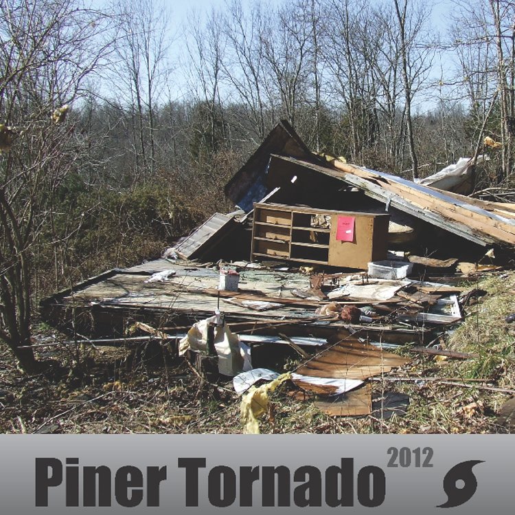
The winning entry was titled “Piner, KY Tornado 2012” The 36 x 48-inch poster map demonstrated the storm’s impacts in detail and how GIS was used by field inspection teams for damage assessment after the EF-4 tornado struck southern Kenton County.

“We didn’t take this topic lightly when choosing to enter this map,” said Hill. “While we’re very much aware that four people died as a direct result of this storm, we felt that this was an opportunity to continue generating positive outcomes from this negative event.”

The most important of these positives was a new emergency warning siren installed in the Piner community. Much of this project was funded with donations from Duke Energy, Owen Electric Cooperative, and the Rotary Club of Kenton County. Before the March 2nd tornado, no emergency warning siren or system existed in the impacted area.

The Piner-Fiskburg Fire Department applied for and received a grant to purchase a new backup generator for the fire station, which did not have one previously. When the storm hit southern Kenton County, most fire stations were without power.

Finally, the paper damage assessment forms used by the Kentucky Emergency Management team to survey field damage have been upgraded to digital forms. First responders can now access the forms on Piner_stonetablet devices such as iPads to record field damage without the need to transfer the information from paper forms to spreadsheets.

The winning map is one in PDS’ series of analytical maps produced through its NKYmapLAB initiative. The initiative analyzes a wide variety of tabular data on a regular basis and presents them in a more visual format that facilitates understanding by the public and its elected leaders.

The Piner Tornado entry was awarded $250 which will be donated to the Kentucky Association of Mapping Professionals (KAMP) Student Scholarship Fund. Hill currently serves as president-elect of KAMP.

For additional information about this project contact Louis Hill, AICP, GISP. The Piner Tornado map and other NKYmapLAB products are available online and on Twitter @NKYmapLAB.

Collaboration, LINK-GIS News, NKYmapLAB, Outreach, Recognition
Award, Emergencies, GIS, KAMP, LINK-GIS, Map, PDS, Piner
In-house GIS collaboration earns Esri Special Achievement Award
Kenton County’s new CodeRED program built atop GIS data
  • Home
  • LINK-GIS News
  • Recognition
  • Outreach
  • NKYmapLAB
  • Collaboration
  • GIS staffer recognized for design work in national competition

Recent Articles

  • Adjusted Operation Details for LINK-GIS
  • How You Can Vote in the Kenton County General Election-November 3, 2020
  • Adjusted Operation Details for LINK-GIS

Archives

  • November 2020
  • October 2020
  • March 2020
  • January 2020
  • March 2019
  • August 2018
  • June 2018
  • December 2017
  • November 2017
  • September 2017
  • August 2017
  • July 2017
  • May 2017
  • April 2017
  • March 2017
  • February 2017
  • January 2017
  • October 2016
  • August 2016
  • July 2016
  • June 2016
  • March 2016
  • December 2015
  • October 2015
  • August 2015
  • February 2015
  • December 2014
  • October 2014
  • August 2014
  • July 2014
  • May 2014
  • April 2014
  • March 2014
  • February 2014
  • December 2013
  • November 2013
  • September 2013
  • August 2013
  • May 2013
  • March 2013
  • March 2012
  • January 2012
  • December 2011
  • February 2011
  • October 2010
  • September 2010
  • August 2010
  • July 2010
  • June 2010
  • March 2010
  • February 2010
  • January 2010
  • December 2009
  • November 2009
  • October 2009
  • September 2009
  • April 2009
  • March 2009
  • October 2008
  • August 2008
  • July 2008
  • May 2008
  • April 2008
  • March 2008
  • January 2008
  • December 2007
  • October 2007
  • August 2007
  • June 2007
  • May 2007
  • April 2007
  • February 2007
  • January 2007
  • November 2006
  • October 2006
  • August 2006
  • June 2006
  • May 2006
  • April 2006
  • February 2006
  • January 2006
  • December 2005
  • September 2005
  • April 2005
  • March 2005
  • February 2005
  • October 2003

LINK-GIS Disclaimer  •  Copyright @2016  •  Planning and Development Services of Kenton County