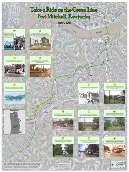
LINK-GIS Timeline

2007

Launch of the WebFOCUS website to the cities under the One Stop Shop Program. Presented WebFOCUS at the Kentucky GIS Conference. NKAPC staff works with PhotoScience, Inc. to provide new aerial photography and updated data for Campbell and Kenton Counties.  This is the first time the technology called LiDAR is used to create a 3D image of the surface instead of just a 2D image used in the past. LINK-GIS Visioning Workshop sets stage for improvements to system.  Facilitators led participants through a celebration of what’s been accomplished collaboratively since LINK-GIS was created in 1985. After almost 25 years and considerable growth in its operations, Northern Kentucky’s LINK-GIS is operating under new partnership accords.  Interlocal agreements creating separate LINK-GIS partnerships for Campbell and Kenton Counties allows for more detailed accountability in financing the system’s operations. Kenton Fiscal Court and NKAPC to pursue Assets Management Program with GPS.

2006

GIS staff helps parents keep track of offenders in their neighborhoods. Senior GIS Specialist Christy Davis accepted an invitation to teach a GIS class at Northern Kentucky University for the fall semester. Northern Kentucky Area Planning’s GIS department works to assist emergency service providers in Pendleton County to improve their response times. WebFOCUS pilot project completed.  This was a pilot of the reporting and mapping capabilities with the City of Fort Wright prior to the January 2007 launch for all cities participating in the One Stop Shop Program.

2005
2005

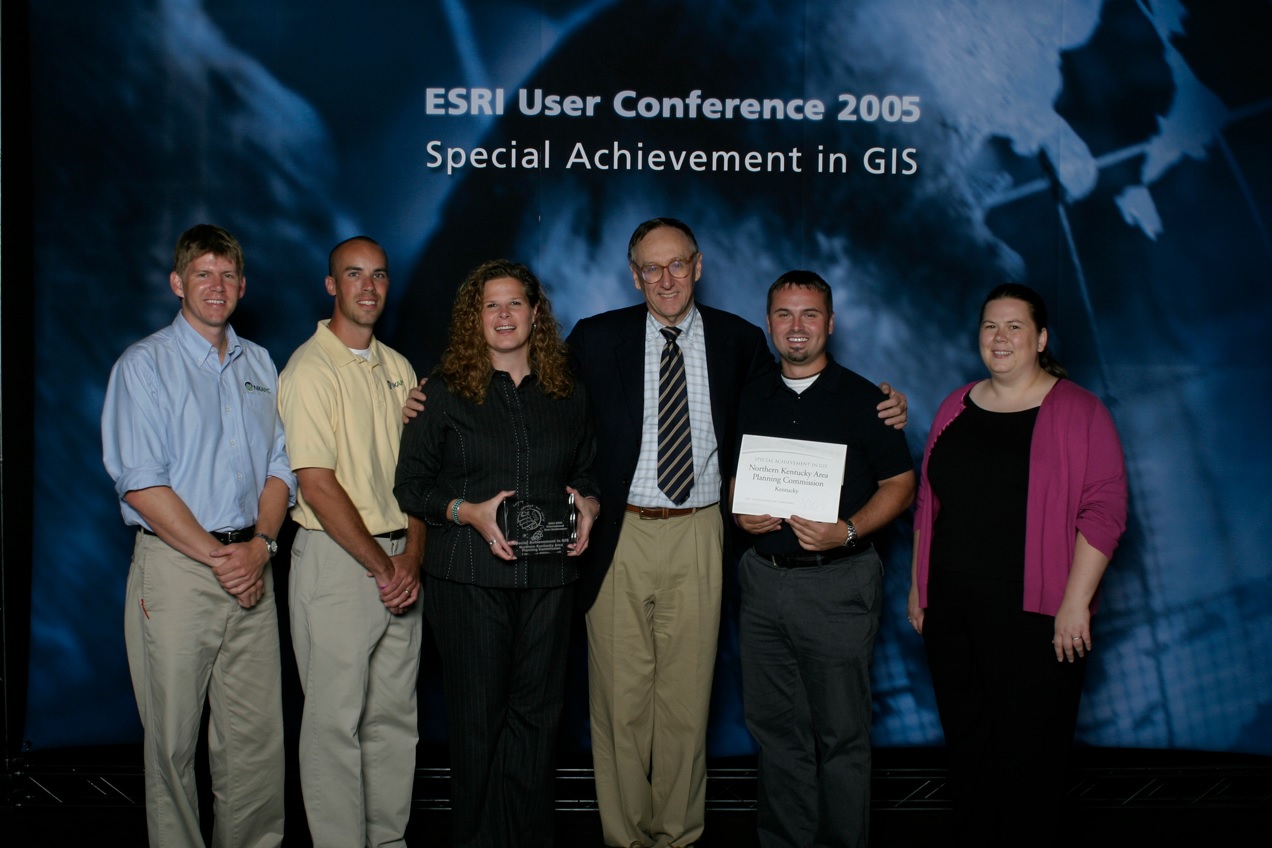
Northern Kentucky Area Planning Commission is awarded Special Achievement in GIS recognition from ESRI. Kenton County Brownfields Initiative awarded Earth Day award by Kentucky Environmental Quality Commission, Kentucky League of Cities, and Kentucky Association of Counties. Staff member Christy Davis presented a session about GIS marketing at the ESRI International User Conference. Staff member Ryan Kent invited to present at the National EPA Brownfields Conference. Article in the February Geospatial Solutions magazine called “Sharing Data – Local Government Set the Standard”. The article discussed how the NKY task force developed a set of standards for sharing GIS datasets.

2004

Pendleton County Fiscal Court and Pendleton County PVA join the partnership. Staff members from the partnership present a session about three county data standards at the ESRI International User Conference. Updated aerial photography for Kenton and Campbell Counties featuring with new roads and buildings is completed.

2003

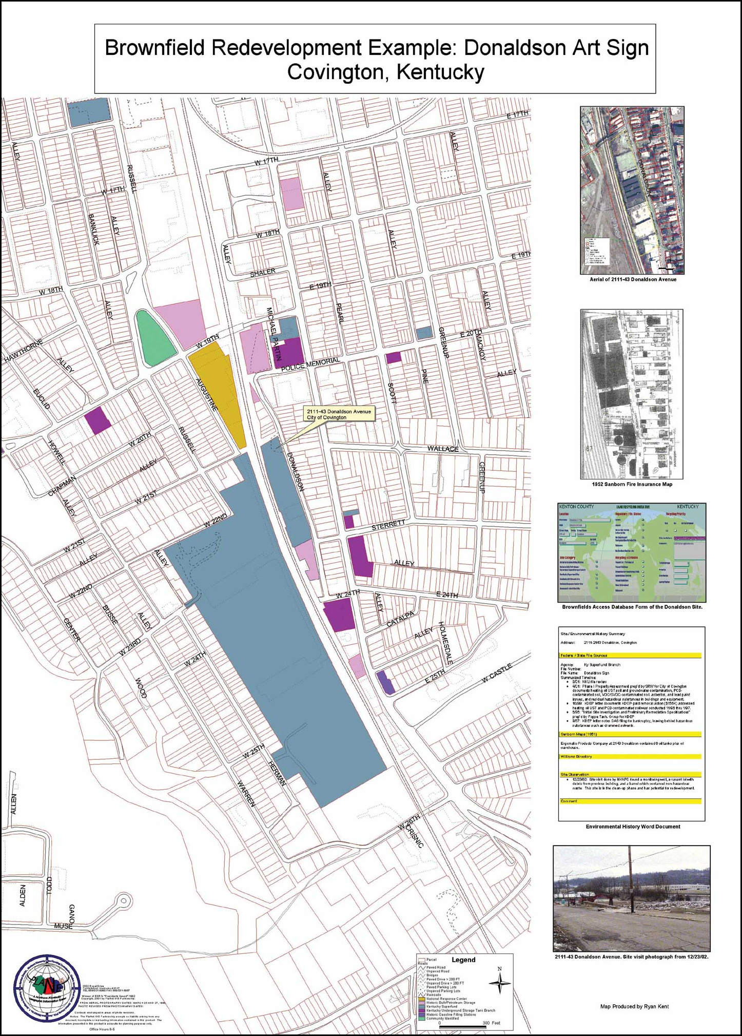
The partnership launches an internet mapping website powered by ESRI’s ArcIMS. Staff members from the partnership are instrumental in helping found the Kentucky Association of Mapping Professionals (KAMP). Three of these staff members go on to serve on the board of directors. An article entitled “Kenton County Lead Way in Brownfield Redevelopment” written by staff member Ryan Kent appears in the October-December 2003 edition of ArcUser Magazine.

2002

Campbell County Fiscal Court and Campbell County Property Valuation Administration join the partnership. The partnership along with Boone County establishes a monumentation network for the three county area. An image from the Kenton County Comprehensive Plan Update map is featured in the opening ceremony for the ESRI International User Conference.

1999

The partnership undertakes a major update that increases the accuracy of the data in the urban area of the county to 1″=100′. This update also provides 2′ topography and color aerial photography with 6″ resolution.

1995

The partnership is awarded Best Map in the URISA ‘95 Project Showcase for Automated Identification of Sanitary Sewer Systems.

1994

The Northern Kentucky Water District joins the partnership. A map entitled “Automated Identification of Sanitary Sewer Transfer Points and Combined Sewer Overflows” is printed in the ESRI Map Book, an annual publication dedicated to acknowledging the important and innovative accomplishments of GIS users around the world.

1993

A map entitled “GIS Applications in Northern Kentucky” is printed in the ESRI Map Book, an annual publication dedicated to acknowledging the important and innovative accomplishments of GIS users around the world.