

Tags
Zoning, planning, Kentucky, Campbell County Department of Planning & Zoning, LINK-GIS, Planning and Development Services of Kenton County (PDS), Campbell County, Campbell County Fiscal Court
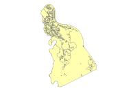
Summary
This data set represents the zoning for Campbell County. The data set was created by LINK-GIS/PDS and is updated in collaboration with The Planning, Zoning and Building Inspections Department of Campbell County KY and the cities in Campbell County. Data Product is primarily intended for display, analysis, planning purposes, community development projects, and GIS-related analyses. The data contained in this data product are not intended for property taxation purposes. This Data Product is stored, edited and maintained as polygon geometry. The Campbell County Zoning data may change at any time, with or without notice.
Description
This data set represents the zoning for Campbell County. The zoning regulations and districts are presented in accordance with an adopted Comprehensive Plan for Campbell County to promote the public health, safety, morals and general welfare of the county, to facilitate orderly and harmonious development and the visual or historical character of the county, and to regulate the density of population and intensity of land use in order to provide for adequate light and air. An ordinance dividing the county of Campbell, Commonwealth Of Kentucky, into zones. Zones of such shape and area as are deemed best suited to carry out these regulations: regulating the location, height, number of stories and size of buildings and other structures: regulating the size of yards and other open spaces and the density and distribution of population and the uses of buildings, structures and land for residential, commercial, industrial, and other purposes: providing for enforcement; a board of adjustment and repealing all regulations, resolutions, orders, ordinances and/or codes in conflict with this ordinance
The data set was created by LINK-GIS/PDS and is updated in collaboration with The Planning, Zoning and Building Inspections Department of Campbell County KY and the cities in Campbell County. Data Product is primarily intended for display, analysis, planning purposes, community development projects, and GIS-related analyses. The data contained in this data product are not intended for property taxation purposes. This Data Product is stored, edited and maintained as polygon geometry. The Campbell County Zoning data may change at any time, with or without notice.
Credits
LINK-GIS, Planning and Development Services of Kenton County (PDS), Planning, Zoning and Building Inspections Department of Campbell County KY
Use limitations
All Users hereby acknowledge that PDS, LINK-GIS and any, or all, of its partners or employees accept no liability for use of this Data Product. These Data Products have not been prepared for, and are not suitable for engineering, or surveying purposes. Generally, these Data Products do not represent on-the-ground surveys, but rather represent the approximate relative location of boundaries and features. These Data Products are for general planning purposes only, no other intent is implied. Products should not be used for making financial or any other commitments. PDS, LINK-GIS and any, or all, of its partners or employees provide these Data Products with the understanding that they are not guaranteed to be accurate, correct or complete and conclusions drawn from the Data Products are the responsibility of the User. While every effort has been made to ensure the accuracy, correctness and timeliness of materials presented anywhere within the Data Products, PDS, LINK-GIS and any, or all, of its partners or employees assumes no responsibility for errors or omissions, even if advised of the possibility of such damage.
Extent
West -84.506077 East -84.232771
North 39.122211 South 38.805590
Scale Range
Maximum (zoomed in) 1:5,000
Minimum (zoomed out) 1:500,000