

Tags
Campbell County, Kentucky, ZIP Code, areas, five-digit ZIP Codes, post offices, location, society, boundaries
Summary
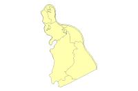
This dataset represents the Zip Code areas in Campbell County and is stored, edited and maintained as polygon geometry. This layer is primarily intended for display, analysis, and mapping for current planning purposes, community development projects, and GIS-related analyses, and the data contained in this data set are not intended for property taxation purposes. This Data Product may change at any time, with or without notice.
Description
U.S. ZIP Code Areas represents five-digit ZIP Code areas used by the U.S. Postal Service to deliver mail more effectively. The first digit of a five-digit ZIP Code divides the United States into 10 large groups of states (or equivalent areas) numbered from 0 in the Northeast to 9 in the far West. Within these areas, each state is divided into an average of 10 smaller geographical areas, identified by the second and third digits. These digits, in conjunction with the first digit, represent a Sectional Center Facility (SCF) or a mail processing facility area. The fourth and fifth digits identify a post office, station, branch or local delivery area. Usually the zip codes are assigned to geographical areas. However, special codes are sometimes assigned to individual addresses or to institutions that receive large volumes of mail, such as government agencies and large commercial companies Like Northern Kentucky University, ZIP CODE 41099.
This dataset represents the Zip Code areas in Campbell County and is stored, edited and maintained as polygon geometry. This layer is primarily intended for display, analysis, and mapping for current planning purposes, community development projects, and GIS-related analyses, and the data contained in this data set are not intended for property taxation purposes. This Data Product may change at any time, with or without notice.
Credits
US Postal Service, USPS, LINK-GIS, Planning and Development Services of Kenton County (PDS)
Use limitations
All Users hereby acknowledge that PDS, LINK-GIS and any, or all, of its partners or employees accept no liability for use of this Data Product. These Data Products have not been prepared for, and are not suitable for engineering, or surveying purposes. Generally, these Data Products do not represent on-the-ground surveys, but rather represent the approximate relative location of boundaries and features. These Data Products are for general planning purposes only, no other intent is implied. Products should not be used for making financial or any other commitments. PDS, LINK-GIS and any, or all, of its partners or employees provide these Data Products with the understanding that they are not guaranteed to be accurate, correct or complete and conclusions drawn from the Data Products are the responsibility of the User. While every effort has been made to ensure the accuracy, correctness and timeliness of materials presented anywhere within the Data Products, PDS, LINK-GIS and any, or all, of its partners or employees assumes no responsibility for errors or omissions, even if advised of the possibility of such damage.
Extent
West -84.504762 East -84.231746
North 39.121951 South 38.805617
Scale Range
Maximum (zoomed in) 1:5,000
Minimum (zoomed out) 1:625,000