

Tags
Water line, Water, NKWD, Water District, structure, utilitiesCommunication, Campbell County, Kenton County, Kentucky
Summary
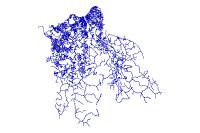
Owner and material for the water line ducts in Kenton and Campbell County
Description
Owner and material for the water line ducts in Kenton and Campbell County
Credits
Northern Kentucky Water District, NKWD, LINK-GIS, Planning and Development Services of Kenton County (PDS)
Use limitations
All Users hereby acknowledge that PDS, LINK-GIS and any, or all, of its partners or employees accept no liability for use of this Data Product. These Data Products have not been prepared for, and are not suitable for engineering, or surveying purposes. Generally, these Data Products do not represent on-the-ground surveys, but rather represent the approximate relative location of boundaries and features. These Data Products are for general planning purposes only, no other intent is implied. Products should not be used for making financial or any other commitments. PDS, LINK-GIS and any, or all, of its partners or employees provide these Data Products with the understanding that they are not guaranteed to be accurate, correct or complete and conclusions drawn from the Data Products are the responsibility of the User. While every effort has been made to ensure the accuracy, correctness and timeliness of materials presented anywhere within the Data Products, PDS, LINK-GIS and any, or all, of its partners or employees assumes no responsibility for errors or omissions, even if advised of the possibility of such damage.
Extent
West -84.661350 East -84.241612
North 39.118035 South 38.796977
Scale Range
There is no scale range for this item.