

Tags
City limits, City Boundaries, City boundary lines, LINK-GIS, Planning and Development Services of Kenton County, PDS, Location, Planning, Kentucky, Kenton County
Summary
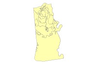
The Kenton County City Boundary layer displays the area covered by the cities in Kenton County and its boundaries. This Kenton County City Boundary Data Product is primarily intended for display, analysis, and mapping for current planning purposes, community development projects, and GIS-related analyses. The Kenton County City Boundary data contained in this data set are not intended for property taxation purposes. This Data Product is stored, edited and maintained as polygon geometry, this Data Product may change at any time, with or without notice.
Description
The Kenton County City Boundary layer displays the area covered by the cities in Kenton County and its boundaries. This Kenton County City Boundary Data Product is primarily intended for display, analysis, and mapping for current planning purposes, community development projects, and GIS-related analyses. The Kenton County City Boundary data contained in this data set are not intended for property taxation purposes. This Data Product is stored, edited and maintained as polygon geometry, this Data Product may change at any time, with or without notice.
Credits
LINK-GIS, Planning and Development Services of Kenton County (PDS)
Use limitations
All Users hereby acknowledge that PDS, LINK-GIS and any, or all, of its partners or employees accept no liability for use of this Data Product. These Data Products have not been prepared for, and are not suitable for engineering, or surveying purposes. Generally, these Data Products do not represent on-the-ground surveys, but rather represent the approximate relative location of boundaries and features. These Data Products are for general planning purposes only, no other intent is implied. Products should not be used for making financial or any other commitments. PDS, LINK-GIS and any, or all, of its partners or employees provide these Data Products with the understanding that they are not guaranteed to be accurate, correct or complete and conclusions drawn from the Data Products are the responsibility of the User. While every effort has been made to ensure the accuracy, correctness and timeliness of materials presented anywhere within the Data Products, PDS, LINK-GIS and any, or all, of its partners or employees assumes no responsibility for errors or omissions, even if advised of the possibility of such damage.
Extent
West -84.623627 East -84.417659
North 39.100217 South 38.789881
Scale Range
Maximum (zoomed in) 1:5,000
Minimum (zoomed out) 1:500,000